Extra News Alerts
Get breaking updates as they happen.

As the calendar turned to December and meteorological autumn transitioned into winter, you are not alone if you have been thinking about how much snow and cold we’re going to get over the next few months.
Winter is the season when we all know the weather can be annoying — either moderately impeding or wreaking havoc with our ability to get around. Other than the small chance of a hurricane and occasional severe weather in the summer, the colder months definitely are our high-impact season.
There are, after all, a plethora of forecasts out there for the upcoming winter, all of them based on relatively the same data, but each includes some nuance in how the data are interpreted.
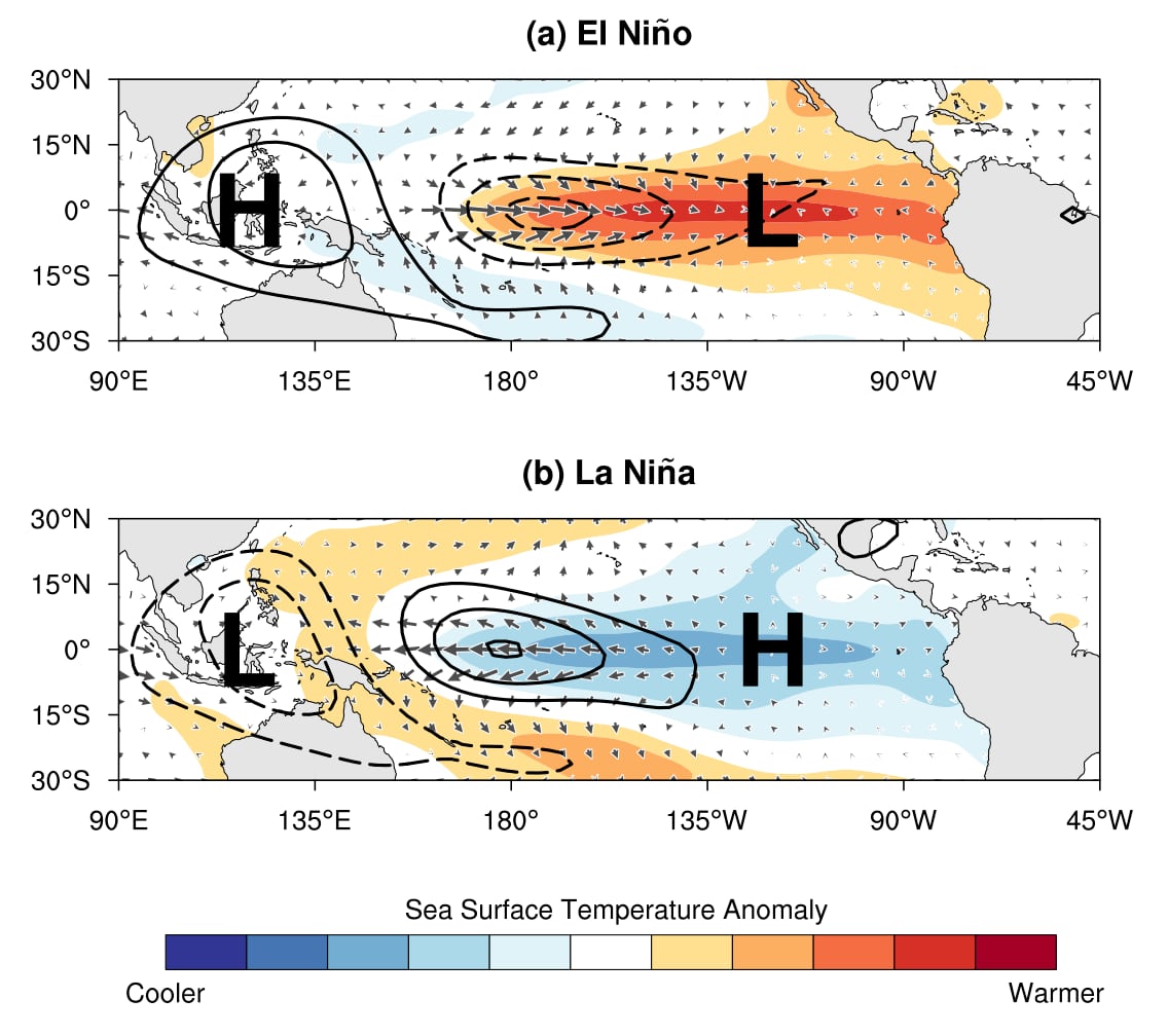
The big players in winter weather are often what’s happening with ocean temperatures, and large scale, ever-present wind and pressure systems. There are particular contenders that are the standouts of the seasonal forecast stage. I would put the El Niño-Southern Oscillation as well as the Indian Ocean Dipole at the top of that list.
Other actors can at times take center stage and then fade into the background. The Madden Julian Oscillation (MJO), the Arctic Oscillation (AO), the North Atlantic Oscillation (NAO), and the Pacific North American Pattern (PNA) not only impact seasonal weather, but they can play off each other to make forecasting weekly changes in the colder months even more difficult. Sometimes one of these patterns can even lock in so tightly as to overwhelm the others.
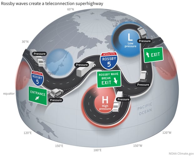
Each of these works by influencing how weekly and monthly patterns unfold. The variables, or teleconnections as they are called, can move and impact the waves of air that carry the jet stream — the key way weather moves across the globe.
Simply put, we know it’s going to get colder and there will be snow, but how the air masses move each winter can be very different and have a very different outcome.

Adding to the mix is a warming climate that puts added pressure on temperatures, making recent winters not as cold as in decades past.
Globally, snowfall is decreasing. But here in eastern New England snow averages went up because of the snowy years between 2008 and 2015.
The global climate system is highly dynamic, and even in a milder than average winter we can have big snowstorms and frigid cold. We only have to look back to last winter when temperatures were well below zero, briefly creating a lot of plant damage in spite of an overall mild season.
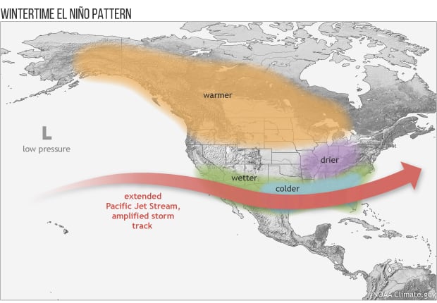
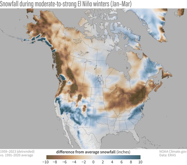
This year, as is typically the case, the biggest player in seasonal forecasting is the El Niño weather pattern. Now in a warm phase, the El Niño is coming on strong and will likely peak later this month.
The chart below shows how snowfall has occurred during moderate and strong El Niño years.
The theme here is that it’s likely that snowfall this winter will be less than average, but it’s almost a lock that we’re going to have more snow than last year — when Boston received about a foot. Average snowfall is around 45 inches for Boston and about 62 inches in the Worcester area.
Snowfall is one of the most inconsistent season-to-season variables we measure. A decade ago, we had 110 inches of snow, while last winter we only saw about a foot.
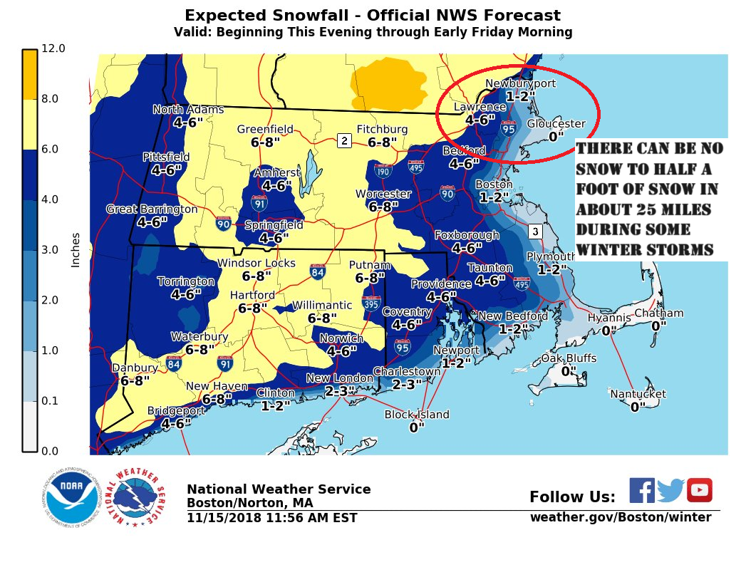
Also, because of our proximity to the Atlantic Ocean and its warming influence, areas along the coastline can see no snow, while 25 miles inland there can be half a foot of snow or more.
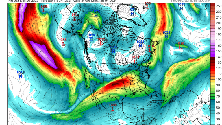
Just look at the map below from a 2018 storm. This is why snowfall prediction is a cautious tale. Just getting a couple of storms that come a little closer to the coastline with some cold air can quickly raise totals. Of course, the opposite is true if multiple storms are out to sea or it’s just slightly too warm.
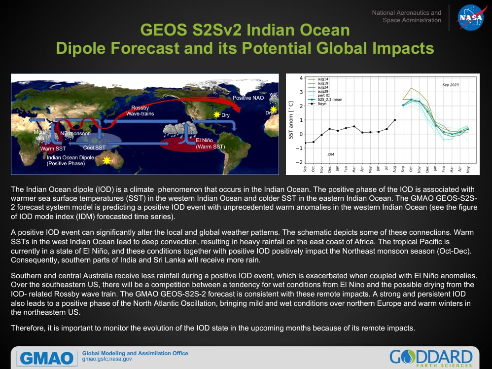
Earlier I referred to other teleconnections influencing global weather. One of them is called the Indian Ocean Dipole (IOD) and this oscillates between warm and cool phases. This year, it’s in the warm phase and that can also put pressure on our weather to be a little warmer than average as well. This is a less studied phenomenon, and we continue to learn how it may or may not be connected to the others.
There are also atmospheric teleconnections that can further influence the weather pattern.
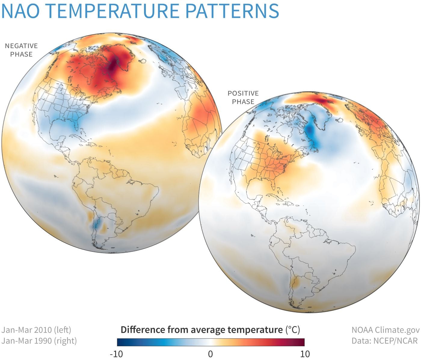
The Arctic Oscillation and the North Atlantic Oscillation are two that can be quite dominant in our local weather. The AO moves between positive and negative phases. In the positive phase, the polar wind is stronger than usual and those winds keep the coldest of the Arctic air locked in to the north.
Sometimes the Arctic Oscillation becomes negative and weakens. This allows the cold air to flop southward. But where it ends up is less predictable. A pool of cold air could end up over in northern Asia or Europe just as easily as in North America.

The North Atlantic Oscillation, or NAO, is a result of low pressure near Greenland and high pressure near the Azores; here again, depending on the difference between these two systems, the jet stream can buckle in a way that provides us with cold and snowy weather or milder than average conditions. All of these different variables just increase or decrease the probability of a particular pattern.
Other areas of warm and cold water in the different oceans, various wind patterns, and even an active or a not so active sun influence our weather.
When you’re shoveling snow here, keep in mind that the storm we experience is a byproduct of countless meteorological and climatological variables. How these interplay with each other is almost like predicting how building a sports team with various talents is going to perform. You might get one player who underperforms and drags the entire team down or you might get one player who becomes a strong leader and takes a team that’s relatively mediocre on paper to the Super Bowl.
Sometimes one of them can start impacting all the rest, and what you thought was going to happen in a particular season doesn’t materialize.
It’s a sure bet the winter ahead will bring cold and snow to New England, including Boston. The likelihood of a blockbuster winter? That’s less than the likelihood of a more typical or even milder winter, but in the “still relatively early game” of seasonal forecasting, anything can happen.
Get breaking updates as they happen.


Conversation
This discussion has ended. Please join elsewhere on Boston.com